About
I am a postdoctoral researcher at the NORSAR research facility in Kjeller, Norway. I investigate subsurface fluid processes, fault zones and subduction zones using seismology. My current research revolves around developing a method to determine moment tensors of small earthquakes. Previously, I worked on detecting and locating earthquakes, computing earthquake magnitudes, determining fault plane solutions and moment tensors, processing receiver function, calculating seismic tomographies, and developing software to learn about earthquakes and Earth’s interior structure.
Research Portfolio
Relative moment tensor method
I continue developing the relative moment tensor method to make it accessible to a wider scientific and industrial audience. The seismic moment tensor delivers valuable information about the physical source process of a seismic event. It allows to distinguish between earthquakes, explosions and volcanic events, constraints the orientation of an earthquake rupture, and represents the most accurate estimate of the released seismic energy. Relative moment tensors rely on less subsurface information than absolute moment tensors and can be computed at 2-3 magnitudes lower, increasing the number of recoverable moment tensors by 100 - 1000. The project is on active development on GitHub and is extensively documented.
Structural imaging and modeling
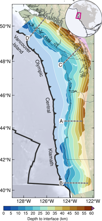 I construct lithosphere-scale structural images and models of the subsurface. For the
Pacific Northwest of North America, my colleagues and I built a structural model
of the subducting Juan de Fuca and Gorda tectonic plates using teleseismic receiver
functions – a method to
image Earth’s interior that uses earthquakes as an energy source, akin to reflection
seismics or ultrasound. The model indicates that the shape of the subducting plate is
controlled by the rigidity and competence of the terranes that make up overriding North
American continent. The subduction stratigraphy thickens down dip, suggesting that slab
material is underplated to the base of coastal North America. The slab model and the
raw receiver functions are freely available from GFZ Data Services. The corresponding
publication appeared in Geochemistry, Geophysics, Geosystems.
I construct lithosphere-scale structural images and models of the subsurface. For the
Pacific Northwest of North America, my colleagues and I built a structural model
of the subducting Juan de Fuca and Gorda tectonic plates using teleseismic receiver
functions – a method to
image Earth’s interior that uses earthquakes as an energy source, akin to reflection
seismics or ultrasound. The model indicates that the shape of the subducting plate is
controlled by the rigidity and competence of the terranes that make up overriding North
American continent. The subduction stratigraphy thickens down dip, suggesting that slab
material is underplated to the base of coastal North America. The slab model and the
raw receiver functions are freely available from GFZ Data Services. The corresponding
publication appeared in Geochemistry, Geophysics, Geosystems.
To reconcile the intricate structure of the Pamir plateau with paleogeographic reconstructions, we conducted local seismic tomography. Together with the location of intermediate depth seismicity, our tomograms reveal the eastern edge of an indenter of the Indian continent that protrudes far north of the Himalaya and is likely responsible for the rise of the protruding Pamir orogen. The 3D tomography and earthquake locations are published through GFZ Data Services. The corresponding publication appeared in Geophysical Research Letters.
Software development
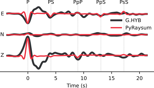 To
do inverse modelling of receiver functions, we overhauled Andrew Frederiksen’s classic
code Raysum and ported it to the Python programming language. PyRaysum is highly
compatible with other research software, is fast, and comes with plotting functionality.
Get a stable version snapshot from Zenodo, follow the project on
GitHub and read the full article in
Seismica: PyRaysum: Software for Modeling Ray-theoretical Plane Body-wave Propagation
in Dipping Anisotropic Media
To
do inverse modelling of receiver functions, we overhauled Andrew Frederiksen’s classic
code Raysum and ported it to the Python programming language. PyRaysum is highly
compatible with other research software, is fast, and comes with plotting functionality.
Get a stable version snapshot from Zenodo, follow the project on
GitHub and read the full article in
Seismica: PyRaysum: Software for Modeling Ray-theoretical Plane Body-wave Propagation
in Dipping Anisotropic Media
Earthquake detection, location, magnitudes, re-location, focal mechanisms, moment tensors
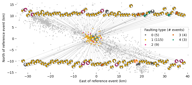
The Pamir highlands of central Asia were struck by an earthquake sequence that lasted over two years in 2015–2017. The initial magnitude 7.2 Sarez earthquake was followed by two more shocks with a magnitude greater than 6 and several magnitude 5 earthquakes. The sequence spread over an unusually large area, lasted long, and affected multiple, dissimilar fault zones.
To understand triggering of the subsequent earthquakes, we relocated tens of thousands of fore- and aftershocks and determined dozens of earthquake moment tensors. The earthquake locations show how the rupture areas of the later main shocks were destabilized by foreshocks. Static stress transfer from one to the next large earthquake was, however, low or even negative. More likely, fluids that have previously been imaged to reside in the middle crust were mobilized by the initial main shock and triggered the subsequent earthquakes.
All results are published in our article in Geophysical Journal International: The 2015–2017 Pamir earthquake sequence: foreshocks, main shocks and aftershocks, seismotectonics, fault interaction and fluid processes. The earthquake catalog and moment tensors are available through GFZ Data Services: Earthquake and Moment Tensor Catalogs of the 2015-2017 Pamir Earthquake Sequence
Subduction processes
Subduction zones form beautiful landscapes around the so-called Ring of Fire that surrounds the Pacific Ocean. They are defined as the geographic regions where the oceanic tectonic plates are drawn beneath the continents by plate tectonics. The recycling of rock, water, sediments and organic matter into Earth’s mantle and their return to the surface trough volcanism is a fascinating process that helps making Earth habitable in countless ways.
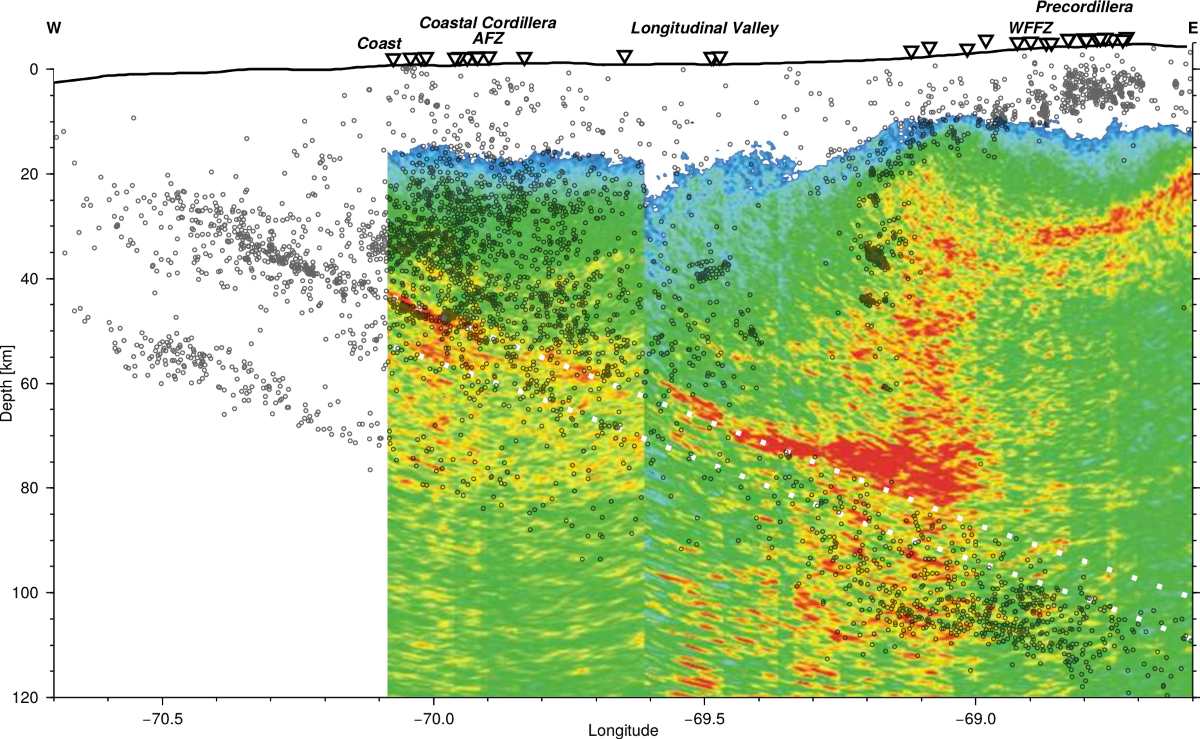
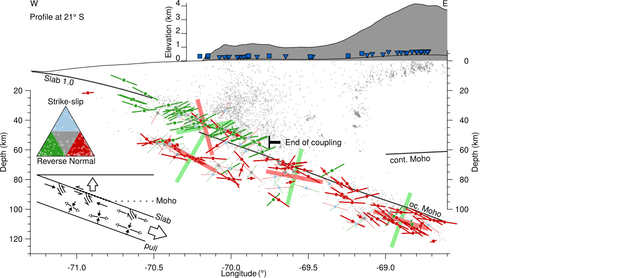
With my colleagues, I investigated subduction processes taking place in the central Andes of northern Chile from a seismological point of view. With a fully manually picked earthquake catalog, we were able to define a triple seismic zone in the down-going oceanic crust that extends to shallower depth than previously imaged. Seismicity of the continental crust reaches the plate interface near the coast. In advance of the volcanic arc, seismicity is constrained to the upper crust, where it’s deepest occurrence defines the brittle-ductile boundary. The results are published in Geophysical Journal International
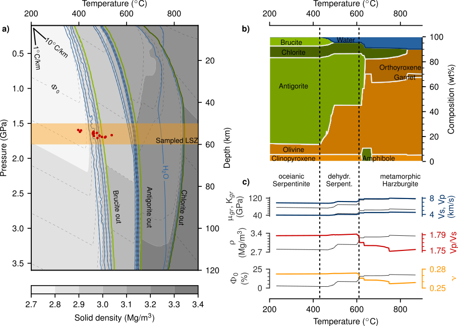 The highly resolved earthquake catalog further allowed us to measure the in-situ rock
physical parameter of the P- to S-wave velocity ratio. The elevated value we found in
the lower seismicity zone indicates the presence of fluids, 40km deep, inside the
oceanic mantle. Through petrophysical and poroelastic modelling, we could demonstrate
that our observations are consistent with the presence of dehydrating vein networks,
similar to those found in outcrops certain serpentinite rocks. The correlation suggests
that serpentinite is dehydrating through veins in the lower band of seismicity of the
central Andean subduction zone. The corresponding article appeared in Geochemistry,
Geophysics, Geosystems.
The highly resolved earthquake catalog further allowed us to measure the in-situ rock
physical parameter of the P- to S-wave velocity ratio. The elevated value we found in
the lower seismicity zone indicates the presence of fluids, 40km deep, inside the
oceanic mantle. Through petrophysical and poroelastic modelling, we could demonstrate
that our observations are consistent with the presence of dehydrating vein networks,
similar to those found in outcrops certain serpentinite rocks. The correlation suggests
that serpentinite is dehydrating through veins in the lower band of seismicity of the
central Andean subduction zone. The corresponding article appeared in Geochemistry,
Geophysics, Geosystems.
With data from focal mechanisms and seismic moment tensors, we could also demonstrate, how slab-pull is the driving force behind plate subduction in the working area. Only where the down-going oceanic plate is coupled to the overriding continent, compression dominates. The full article is accessible in Geophysical Research Letters.